High-Impact Rainfall Event Likely to Exceed Model Forecasts – NE Queensland
- Jan 9
- 4 min read
Issued Friday 9 January 2026


Tropical Low 12U – High-Impact Rainfall and Infrastructure Risk Escalating


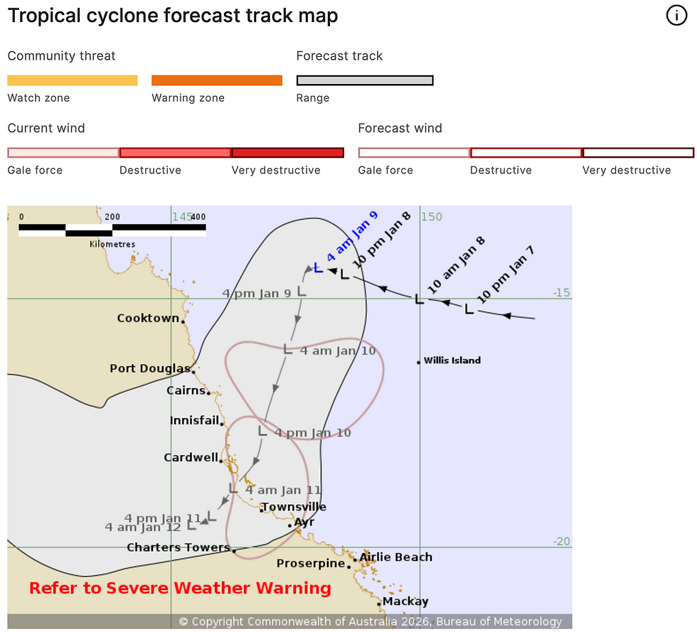
Tropical Low 12U continues to develop in the western Coral Sea and is tracking toward the northeast Queensland coast. While model guidance indicates a moderate risk of cyclone development late Friday into Saturday, the primary and most immediate threat is extreme rainfall, not wind intensity.
This system is entering a high-efficiency rainfall phase, with deep tropical moisture interacting with coastal convergence and terrain effects.
Rainfall Risk – Significantly Higher Than Model Guidance
Rainfall projections from numerical models are likely to substantially understate actual totals as convergence bands consolidate and stall between Cooktown and Mackay.
Key member-level guidance:
• Daily rainfall totals of 200–500 mm are likely
• Isolated pockets may exceed this range, particularly where convergence zones stall or repeatedly redevelop
• Highest risk zones extend from the North Tropical Coast through the Herbert and Lower Burdekin into the Central Coast and Whitsundays

These totals are consistent with slow-moving tropical lows embedded within an active monsoon trough and will drive rapid runoff, flash flooding and prolonged river rises.
Rainfall impacts are expected to persist through Saturday, with some areas likely continuing into Sunday, depending on inland progression of the low.
Flooding and Ground Saturation
Catchments across northeast Queensland are already saturated, significantly increasing runoff efficiency.
• Flash flooding risk is high to extreme
• Riverine flooding will escalate rapidly with renewed rainfall bursts
• Landslip risk increases across steep and hilly terrain
Flood Watches and Warnings already in place should be treated as baseline risk, not worst-case outcomes.
Wind Risk – Secondary but High Impact Due to Soil Saturation
While sustained wind speeds are not expected to be extreme, the impact risk is elevated due to:
• Saturated soils
• Reduced root stability
• Prolonged exposure to squally winds

Key risk:
⚠️ Widespread tree damage is likely, even in moderate wind gusts.
This significantly increases the risk of:
• Power outages
• Blocked roads
• Damage to power networks as trees and limbs fall onto infrastructure
The corridor of highest risk extends from Cooktown to Mackay, including inland and coastal communities.
Critical Preparation – Action Required Today
Friday 9 January 2026
Persons in northeast Queensland should complete preparations today, including:
• Ensure generators are fuelled, tested and fit for service
• Secure loose items around properties
• Prepare for extended power disruptions
• Avoid flood-prone travel routes once rainfall intensifies
• Finalise livestock and asset protection plans
This event carries a high infrastructure disruption risk, even without cyclone-strength winds.
Video discussion:
Warning Summary – Northeast and Northern Queensland
Issued Friday 9 January 2026
This summary consolidates all current warnings in effect across Queensland associated with Tropical Low 12U, the monsoon trough, and ongoing flooding. Conditions are active, escalating and highly disruptive.
Severe Weather – Rainfall and Wind
Severe Weather Warnings are current for:
• North Tropical Coast and Tablelands
• Herbert and Lower Burdekin
• Central Coast and Whitsundays
• Peninsula Forecast District
Rainfall hazards
• Heavy to locally intense rainfall ongoing and forecast to persist through the weekend
• Six-hourly totals:
– 50–100 mm north of Cairns, isolated 180 mm+
– 100–170 mm south of Cairns, isolated 250 mm+
• 24-hour totals:
– 100–180 mm north of Cairns
– 150–250 mm south of Cairns
– Isolated totals exceeding 350 mm possible
⚠️Rainfall totals are likely to significantly exceed model guidance as convergence bands develop and stall between Cooktown and Mackay.
Daily totals of 200–500 mm are likely, with isolated pockets exceeding this range where bands persist.
Wind hazards
• Damaging winds averaging 55–65 km/h, gusts to 90 km/h
• Squally thunderstorms may produce higher local gusts
• Winds expected to shift from easterly to northeasterly through Saturday
⚠️ High tree-fall risk due to saturated soils, increasing the likelihood of:
• Tree damage
• Road blockages
• Widespread power outages from Cooktown to Mackay as trees impact power networks
Tropical System Status
• Tropical Low 12U located in the western Coral Sea
• Moderate risk of tropical cyclone development Friday night into Saturday
• Even without cyclone intensification, impacts remain severe due to rainfall
Flood Watches and Flood Warnings
Flood Watch
Minor to Major flooding possible for coastal rivers between the Daintree and Pioneer Rivers, and across Cape York Peninsula.
Catchments at risk include (but are not limited to):Barron, Mulgrave and Russell, Johnstone, Tully, Murray, Herbert, Ross and Bohle, Haughton, Burdekin, Don, Proserpine, Pioneer, Connors, Isaac, Styx, Normanby, Endeavour, Daintree, Mossman, Black River and multiple Cape York catchments.
Major Flood Warning
• Flinders River – Major flooding continues at Walkers Bend
• Moderate flooding at Richmond
• Further rainfall may cause renewed rises
Moderate Flood Warnings
• Norman River – Moderate flooding continuing at Normanton, expected to exceed 2019 levels
• Herbert River – Renewed minor to moderate flooding likely
• Mulgrave and Russell Rivers – Moderate flooding likely at Peets Bridge, possible at Gordonvale
• Tully River – Moderate flooding possible at Euramo Saturday
• Gilbert River – Flooding continuing
Minor Flood Warnings
• Daintree River – Minor flooding possible at Daintree Village
• Thomson River – Minor flooding continues at Camoola Park, possible at Longreach
• Nicholson River – Elevated river levels continuing
Marine Wind Warnings
Gale Warnings
• Cooktown Coast
• Cairns Coast
• Townsville Coast
• Torres Strait (Saturday)
Strong Wind Warnings
• Peninsula Coast
• Mackay Coast
• North East Gulf of Carpentaria
Hazardous marine conditions are expected through Saturday night.
Cape York and Torres Strait
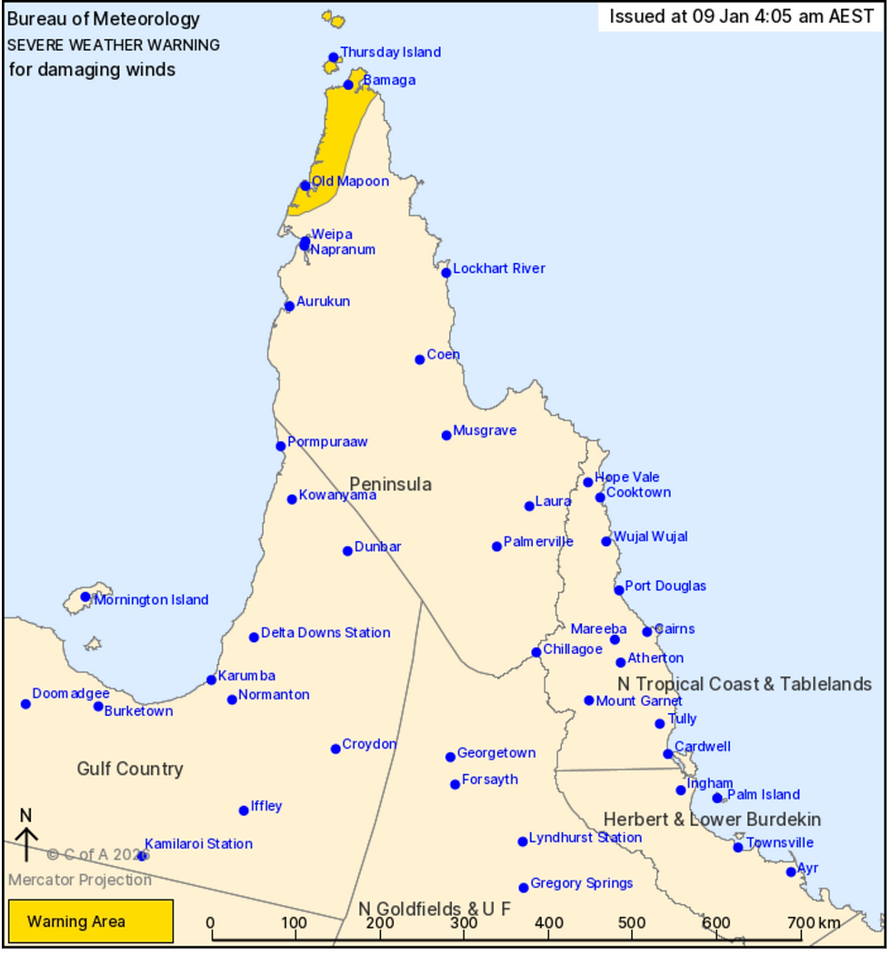
• Severe Weather Warning for damaging monsoonal winds
• Gusts to 90 km/h possible
• Squally showers and thunderstorms
• Conditions easing early Sunday


