top of page

Forecasts


Anzac Day Rainfall Signal Builds as Northwest Cloud Band Develops Across Australia
May shows strong rainfall signals, June continues this trend, and while July appears more average, further events are expected.
August favours the southwest and southeast, while spring shows near to above average rainfall, with increasing storm activity inland.
Despite El Niño and IOD discussions, the current pattern suggests a strong northwest cloud band season, with consistent moisture transport from the Indian Ocean.
Apr 17

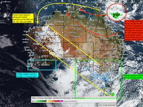
Late-April Rainfall Signal Strengthens as Northern Moisture Links with Southern Systems
Late-April Rainfall Signal Strengthens as Northern Moisture Links with Southern Systems
Apr 13


Southern Seasonal Shift Underway as Frontal Systems Build and Tropical Influence Weakens
Over the past 24 to 48 hours, we have seen the progression of a frontal system that developed across southern Western Australia in week one of the month. This system has now moved through South Australia and into Victoria, aligning well with the long-range forecast for week one and week two.
Apr 10

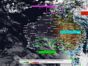
Australia Enters Seasonal Shift as Southern Rainfall Builds Towards Anzac Day
Looking ahead, attention turns to a tropical system developing in the northeast basin between the 9th and 12th. This system, now Tropical Cyclone Maila, is currently a Category 3 system. Most models are taking it across the far north, tracking through the Arafura Sea. This aligns with earlier expectations of a track similar to Cyclone Narelle.
Apr 7


Australia Long Range Weather Update: Cyclone Developments, April Rainfall Signals and El Niño Outlook
Attention then turns very quickly to the next key feature in the pattern, and this is where the forecast becomes far more significant.
From around the 9th to the 12th of April, there is increasing model agreement on the development of a tropical low in the Timor Sea or Arafura Sea region. Sea surface temperatures remain elevated, sitting around 29 degrees, which is more than sufficient to support cyclone development. While we are still some time out, the consistency in the s
Mar 30

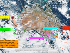
WA Forecast Update Severe Tropical Cyclone Narelle – Final Landfall and Inland Transition
tropical cyclone narelle wa forecast western australia cyclone update narelle rainfall forecast gascoyne pilbara cyclone track australia weather forecast long range weather australia severe weather wa cyclone impacts australia rainfall outlook 2026 season forecast australia cyclone narelle update today
Mar 27

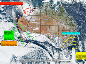
Narelle Strengthens Offshore | Destructive Winds & Storm Tide Threat for WA Coast
Tropical Cyclone Narelle has redeveloped overnight into a Category 1 system and is now entering a critical intensification phase offshore the Pilbara coast.
The key shift in this system is its size and structure. Despite remaining offshore, Narelle is broad enough to extend impacts well inland and along a large stretch of coastline, increasing risk well beyond the immediate core.
Mar 25

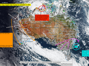
Weekly Weather Update | Narelle – The Long Track Cyclone Reshaping the Season
There are cyclones… and then there are systems like Narelle.
What has unfolded over the past week is not just another tropical system, but a rare, long-track, cross-basin cyclone that has impacted multiple regions across northern Australia and is now set to influence the west coast in the days ahead.
From formation to its current phase, Narelle has followed a highly dynamic and energetic path, aligning closely with what we have identified as the final high-energy tropical w
Mar 23

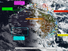
Severe Tropical Cyclone Narelle and High Energy Period Drive National Rainfall and Weather Shift Across Australia
Severe Tropical Cyclone Narelle and High Energy Period Drive National Rainfall and Weather Shift Across Australia
Mar 20


Australia Weather Alert - Cyclone Risk - Inland Flooding - High Energy Period March 2026
A weak tropical low has again shifted south into the central interior, following the inland corridor that has remained active since February. This system has already produced extensive flooding across the Top End and NT interior, along with significant rainfall and renewed flooding through the northern pastoral districts of South Australia.
Mar 17


Expanding High Energy Phase Into April Supporting Inland Cyclone Pathways Across Australia
Video Summary: Today’s video update discusses the building national weather phase currently developing across Australia, bringing a renewed round of storm activity through southern Western Australia, South Australia, Victoria and New South Wales. This emerging phase is also helping to re-establish long-range atmospheric pathways linking northern Australia with the south and south-east. These corridors are a critical component of both historical rainfall patterns and upcoming
Mar 13


High Energy Period 15–18 March Driving Inland Rainfall Expansion Across Australia
A high energy weather period between 15 and 18 March will help drive a northwest cloud band across central Australia delivering rainfall through the interior and northern South Australia while storms continue across the north and coastal showers persist along eastern Queensland.
Mar 13


Multiple Tropical Lows Deepen Across Northern Australia | Cyclone Risk Builds From WA To Queensland
An active week is unfolding across northern Australia as multiple tropical lows develop across several basins from Western Australia to Queensland. Tropical Lows 28U, 29U, 30U and 31U are expected to evolve over the coming days, increasing the risk of cyclone formation and associated severe weather impacts across parts of the tropics.
Mar 4


Severe Weather Update 25.2.2026
Renewed flood risk is developing for Queensland, while tropical cyclone risk is increasing for the Pilbara and Mid West of Western Australia.
This next phase may deliver another prolonged rainfall period across the northeast and parts of the west.
Feb 25


Australia Rainfall Outlook: SA and Victoria Watching WA Tropical System 25U into Late February 2026
This update focuses on the evolving rainfall setup for South Australia and Victoria, heavily influenced by WA tropical development through late February 2026.
Feb 18


Australia Weather Update Tropical Low 23U - Severe Storm Risk and Emerging Seasonal Shift for the south.
The remnants of Mitchell are now expected to be swept eastwards across the Bight, driven by an advancing southern frontal system. As this occurs, residual moisture will support isolated coastal showers across far southern South Australia, while increasing storm activity is more likely across southern Victoria, extending into north east Victoria.
Feb 11


Multi-System Weather Threat: Cyclone Mitchell, Eastern Severe Storm Risk and Tropical Low 23U Watch
Multi-System Weather Threat: Cyclone Mitchell, Eastern Severe Storm Risk and Tropical Low 23U Watch
Feb 9


Australian Weather Update | Tropical Systems & National Rainfall Outlook | TL21U
This update covers:
• TL21U evolution and current rainfall efficiency
• Coral Sea tropical development signals
• Western and eastern tropical system outlooks
• Interior rainfall potential and confidence levels
• Key areas to monitor over the coming week
Feb 6


Australian Weather Update - TL21U, Storm coverage & Future Cyclone Risk
Widespread showers, thunderstorms and rain areas are delivering 10–50 mm across much of the Top End, including the Darwin Daly, Arnhem, Roper and Victoria River districts, with embedded rainbands producing localised totals of 50–150 mm. Had this low been embedded within a stronger monsoon phase, daily falls of 50–100 mm or more would typically be expected, with rainbands capable of producing isolated pockets of 50–300 mm+. This highlights the comparatively suppressed nature o
Feb 4


bottom of page