top of page

Forecasts


National Weather Update – Tropical Low 16U Drives Heavy Rainfall Risk Across the Kimberley and WA Interior
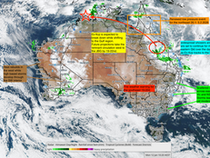
A very active wet season signal continues across northern Australia, with Tropical Low 16U the primary driver for the northwest through Friday to early next week, and a separate Coral Sea low (17U) maintaining showers and coastal convergence risk for far north Queensland while generally staying offshore. Inland Australia stays largely suppressed away from the tropical moisture corridors, but a renewed inland moisture feed is likely to push rain areas and storms further into t
Jan 22


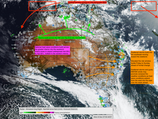
High Energy Period Triggers Cyclone Risk in the Northwest as Heatwaves Dominate the Interior and Storm Bands Build Across Eastern Australia
High Energy Period Triggers Cyclone Risk in the Northwest as Heatwaves Dominate the Interior and Storm Bands Build Across Eastern Australia
Jan 19


From Silence to Surge: Australia’s Weather Resets as the Next Cyclone Phase Ignites from 19–22 January
Following on from the major cycle that was forecast to conclude around the 11th, an interesting and important observation is now emerging. Once Tropical Cyclone Koji crossed the coast on the 11th, the period of widespread high-impact rainfall effectively ended. Since that point, even though Ex-Koji has continued to track across the interior, rainfall has been far more fragmented and localised, occurring mainly in pockets of convection near the remnant circulation rather than
Jan 14


Australia Enters a Dual-Extreme Weather Phase as Cyclone Flooding Dominates the North and Heat and Fire Risk Dominates the South
During the recent major weather period, Tropical Cyclone Koji crossed the Queensland coast to the south of Townsville, between Ayr and Bowen. The system delivered damaging winds extending south through the Mackay and Whitsundays region, along with widespread heavy rainfall that penetrated well into the Central Queensland interior.
Daily rainfall totals in the range of 50 to 300 mm were recorded across multiple districts, with locally higher totals in areas exposed to persist
Jan 12


Australian Long Range Weather Forecast – Australia – August 2026
Week Four Part Two — 27th August to 1st September 2026Primary Wet Window and First Spring Storm Signal
This second period is the wettest and most dynamically significant window of August, marking the transition from late winter into early spring-type storm behaviour.
Jan 9


High-Impact Rainfall Event Likely to Exceed Model Forecasts – NE Queensland
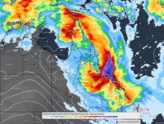
Tropical Low 12U continues to develop in the western Coral Sea and is tracking toward the northeast Queensland coast. While model guidance indicates a moderate risk of cyclone development late Friday into Saturday, the primary and most immediate threat is extreme rainfall, not wind intensity.
Jan 9


Australia Weather Outlook: Tropical Low 12U Drives Flood Risk in the North as Fire Danger Escalates Across the South
Australia is entering a high-impact weather period, with multiple hazards unfolding simultaneously across different regions. The national pattern remains sharply divided, with a developing tropical system bringing increasing flood and wind risk to the northeast, while extreme heat, dryness and escalating fire danger continue across the south and southeast. The lack of overlap between these regimes is critical, as there is no rainfall relief forecast for fire-prone southern re
Jan 8


Market Update - Crypto Swing Low
The 5–6 January low confirms the cycle alignment. The focus now shifts to how price behaves approaching 108 k. A clean breakout will confirm a continuation of the long-term uptrend, while a rejection there would suggest the next correction phase into the 60–70 k zone.
Jan 6


High Energy Period 30 Dec – 11 Jan: National Multi-Hazard Flooding and Heat Event
Australia remains in an exceptionally high-energy pattern, with multiple hazards occurring simultaneously. The key theme through to the 11th is the continued dominance of the monsoon in the north and northeast, while dangerous heat and fire weather escalate across southern and western regions.
Jan 5


Where Can Farmers Get Reliable Long-Range Rainfall Forecasts in Australia?
Australian farmers need reliable long-range rainfall forecasts to support planting, stocking, and financial planning months ahead. This article explains where farmers can access dependable long-range rainfall forecasting in Australia and why early identification of rainfall phases, dry transitions, and persistent weather patterns provides a clear advantage over traditional seasonal outlooks.
Jan 3


Member Short - Long Range Video Update
Short to Long Range Outlook | Severe Weather Update
Today’s video provides a full breakdown of Australia’s current severe weather conditions and what lies ahead over the coming weeks.
Dec 31, 2025


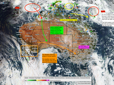
High-Impact Weather Nationwide: Flood Risk, Tropical Rainfall and Fire Danger Unfold
Satellite imagery 31.12.2025
Dec 31, 2025


Market Update
Metals & Crypto Update. Metals - Gold 3Monthly Super Cycle Gold (XAU/USD) Current Daily Price Structure Spot gold recently reached new all-time highs above ~US$4,500/oz before profit-taking and broader market reactions pulled price back slightly. Daily chart shows a well-defined bullish uptrend channel, with price making higher highs / higher lows since mid-2025. Key Levels Support zones: ~US$4,400 – US$4,450 (short-term) and deeper support ~US$4,000 – US$4,100 (major range b
Dec 30, 2025


High Energy Period leads to extensive flood risk for
A prolonged weather event is expected to persist into 7–11 January 2026, continuing the active monsoonal pattern that has dominated since late December.
A key contributing factor lies in a series of Earth-facing coronal holes that developed during week four of December 2025, a phenomenon that was highlighted in previous Oz Industries Forecasting updates.
Dec 29, 2025


Best Long-Range Weather Forecasts in Australia
Best Long-Range Weather Forecasts in Australia | Oz Industries Forecasting
Dec 28, 2025


Australian Weather Weekly Update. HEP 18-24th followed by HEP 30.12.2025-11.1.2026
The High Energy Period (HEP) from 18 to 24 December is now moving through its peak phase. The 21 to 24 December window has proven to be the wetter segment of this period, with a marked increase in thunderstorm activity across the southeast over recent days.
Areas of southeast South Australia, Victoria, New South Wales and parts of southern Queensland have experienced a surge in storms, with recorded rainfall totals generally ranging from 5 to 50 mm, and isolated pockets of 5
Dec 22, 2025


High Impact - Severe Weather builds - late December into week 2 of January 2026
As the monsoon strengthens, high-impact rainfall is forecast to build across the northeast from late December, continuing into early January 2026, with the most intense period likely between 31 December and 11 January.
Dec 19, 2025


Long Range Weather Forecast – Australia – July 2026
Core winter circulation dominates Australia, with continued cooling
and evolving rainfall signals through July.
Dec 18, 2025


Australia Weather Outlook | Late December to January 2026
In today’s update, we unpack the next major weather cycle set to unfold from late December leading into the first tropical phase of the 2025–2026 season across northern Australia.
Expect a noticeable build-up of heat, moisture, and storm energy through the north and northeast, with high-impact rainfall likely developing into week two of January 2026.
Dec 16, 2025


Weekly Weather Update - National Rainfall HEP 18-24th December
Monday 15 December to Sunday 22 December
This week is shaping up as a classic pre Christmas contrast across Australia.Heat dominates the north and interior, while the south experiences very strong winds, rough seas and sharp temperature swings. As we move toward 18 to 24 December, the atmosphere becomes more energetic, increasing the risk of severe thunderstorms and localised heavy rain, especially inland and across parts of the east.
Dec 15, 2025


Australia Weekly Forecast - December 18-24th Wet Period Build Up
Australia is under a broad summer heat regime, dominated by a strong subtropical ridge and slow-moving trough.The northern tropics remain storm-active, the east coast faces sporadic storms leading to isolated heavy rain and localised flash flooding under a coastal trough, while the southern inland and west experience persistent heat and fire danger, punctuated by frontal wind surges and a cooler change early next week.
Dec 12, 2025


Australia: Weekly Weather & Fire Weather Outlook
Australia remains under a dominant heat regime this week, extending from the Pilbara and Interior through South Australia into inland NSW and Queensland. Maximums of 40–45 °C are widespread, accompanied by gusty north-westerlies and very dry air.
Dec 10, 2025


Market Update 8.12.2025
Bitcoin continues to respect the broader corrective structure that has been in place since the speculative peak earlier this year. Price is currently trading near 91,000 USD and is now pressing directly into the major downtrend line that has capped every rally since September. This is an important pressure point for the short-term outlook.
Dec 8, 2025


Weekly Weather Update 8.12.2025
How a failed spring and a moving drought corridor set the scene
Over the past few days, communities across New South Wales, Victoria and Tasmania have been hit by fast moving bushfires that have destroyed homes, cut roads and forced evacuations.
In New South Wales, a natural disaster has been declared after almost forty homes were lost across several local government areas, including the Central Coast, Mid Coast, Upper Hunter, Muswellbrook, Warrumbungle and Dubbo.
Dec 8, 2025
bottom of page