top of page

Forecasts


Australia: Weekly Weather & Fire Weather Outlook
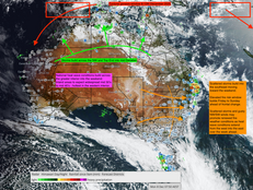
Australia remains under a dominant heat regime this week, extending from the Pilbara and Interior through South Australia into inland NSW and Queensland. Maximums of 40–45 °C are widespread, accompanied by gusty north-westerlies and very dry air.
Dec 10, 2025


Market Update 8.12.2025
Bitcoin continues to respect the broader corrective structure that has been in place since the speculative peak earlier this year. Price is currently trading near 91,000 USD and is now pressing directly into the major downtrend line that has capped every rally since September. This is an important pressure point for the short-term outlook.
Dec 8, 2025


Weekly Weather Update 8.12.2025
How a failed spring and a moving drought corridor set the scene
Over the past few days, communities across New South Wales, Victoria and Tasmania have been hit by fast moving bushfires that have destroyed homes, cut roads and forced evacuations.
In New South Wales, a natural disaster has been declared after almost forty homes were lost across several local government areas, including the Central Coast, Mid Coast, Upper Hunter, Muswellbrook, Warrumbungle and Dubbo.
Dec 8, 2025


National Weather Update: Current Conditions and December Outlook
Today’s update covers the developing weather signals across Australia as we transition from the current dry and heating phase into the next High Energy Period and tropical cyclone genesis window due 8 to 12 December.
Dec 4, 2025


November 2025 Rainfall Deciles Confirm Peak Spring Rainfall and Emerging Southeastern Drought Risk as Tropical Cyclone Genesis Builds in the West
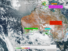
The pattern ahead sets the stage for the next High Energy Period, focused primarily over the western basin from 8–12 December. Current model guidance indicates Cyclone Genesis near 112–114° E, with the system expected to drift south toward the Pilbara coast by mid-month.
Secondary tropical lows are likely to form across the Arafura Sea and near 160° E between Vanuatu and New Caledonia, each forecast to track southeastward.
Dec 1, 2025


Essential Preparation Tips for Your Home and Family During Australia's Cyclone Season
Cyclone season guide with early-warning insights from Oz Industries Forecasting, including home prep, safe rooms and cyclone kit essentials.
Nov 28, 2025


High Energy Period 28–30 November: Severe Storms, Heat & Fire Weather
28 November 2025 Severe Weather & Heatwave Overview
Nov 28, 2025


Impact of Australia’s Severe Weather Events from 19 to 24 High Energy Period November 2025
Oz Industries Forecasting identified 19 to 24 November as a High Energy Period months ahead, signalling a likely rise in severe weather. The atmosphere responded on cue with Cyclone Fina, extreme inland heat, giant hail, destructive storms and widespread thunderstorm activity across Australia. Global volcanic and seismic events also peaked during the same window, further validating the timing signal.
Nov 27, 2025


Market Update Gold & Silver
Gold continues to demonstrate remarkable strength, holding near USD 4,150–4,200/oz, up more than 4 % this monthas capital rotation into tangible assets accelerates. The move confirms the sustained upward momentum that began in 2018 and has now entered the late-cycle acceleration phase — the same structural stage that preceded the 2011 peak.
Nov 27, 2025


December 2025 Review: High-Energy Weather Windows and Tropical Risk Outlook
December marks the transition into early summer, with increasing solar input, warmer surrounding seas and the build-up of the northern wet season. From August through November, rainfall decile patterns have maintained a strong contrast of a drier trend across the south-east and eastern interior, and a wetter to average signal across the north-west and western regions.
By averaging the four-month decile trend, December shows a clear continuation of this divide: drier in the s
Nov 26, 2025


Crypto Phase Transition Ahead: Key Signals to Watch Into 2026
Until a confirmed low forms on the daily or weekly timeframes this remains a wait and see environment. Planning should assume that price decline can remain an extended feature.
Nov 25, 2025


Cyclone Fina Peaks – Extreme Heat and Severe Storms Spread Nationwide
The current High Energy Period (19–24 November) reaches its peak today, coinciding precisely with the maximum intensity of Severe Tropical Cyclone Fina. The system is now beginning to weaken and will continue tracking southwest towards the North Kimberley coast and Mitchell Plateau from 25 November onwards.
Nov 24, 2025


Weekend Weather Update 21.11.2025
A highly dynamic national pattern is unfolding, driven by Tropical Cyclone Fina across the northern Top End, widespread severe heat across inland Australia, and increasing thunderstorm activity along the eastern seaboard.
Nov 21, 2025


Australia's Climate Outlook for December 2025 to June 2026: Key Drivers and Energy Trends
Australia’s Six-Month Outlook: December 2025 – June 2026
How Climate Drivers and High-Energy Periods Shape the Season Ahead
Nov 21, 2025


Tropical Cyclone Fina Update – Alignment with the 19–24 November High-Energy Period
Tropical Cyclone Fina Update – Alignment with the 19–24 November High-Energy Period
Nov 19, 2025


The Cycle Has Turned: What the Charts Now Confirm About Bitcoin’s Four-Year Peak
For those who arrived late to the 2024–2025 bull market, this is not a setback. You are now in a prime position to plan your re-entry during the corrective phase and prepare for the next expansion - one that may again carry Bitcoin toward the $180,000–$220,000 region.
This is the time to plan, position and prepare, not to disengage.
Nov 18, 2025


High Energy Period 19-24th Intensifies: Tropical Low 02U and the Escalation of National Severe Weather
High Energy Period 19-24th Intensifies: Tropical Low 02U and the Escalation of National Severe Weather
Nov 17, 2025


Australia Climate & Weather Briefing – Mid November 2025
Australia Climate & Weather Briefing – Mid November 2025
Nov 13, 2025


Long Range Weather Forecast – Australia – June 2026
June occupies a pivotal position in Australia’s annual climatic cycle. In the southern half of the continent, it marks the full transition into the cooler, wetter winter half of the year, while in the far north it forms part of the peak dry‐season period. The June solstice (usually about 21 June) signals the minimum solar input for the Southern Hemisphere: day-length is at its shortest, and solar radiation is reduced. For farmers this is a key seasonal marker—soil temperature
Nov 12, 2025


Solar Surge Powers Australia’s Late-Spring Storm Peak — November 2025 Outlook
Severe-Weather Synopsis
A broad storm corridor from WA Interior → SA → QLD → eastern NSW peaks mid-week.
Damaging winds, large hail, and flash-flooding possible in QLD interior and northern NSW.
Heatwave early week across the north and west; humidity surge by mid-week.
Tropical build-up strengthening; next west-to-east convective phase due ~19 Nov.
Nov 10, 2025


National Weather Update and Weekly Outlook
Satellite 7.11.2025 Solar Activity Overview Solar activity has intensified significantly during the past fortnight, with several X-class flares recorded. These are the strongest flares observed since the major June event and occurred within the most recent High Energy Period from 29th October to 5th November. X1.8 Flare This solar uplift arrived precisely as Australia experienced the wettest national window of spring to date. The overlap between enhanced space-weather activit
Nov 7, 2025


The Four-Year Cycle: Fear, Patience, and the Importance of Physical Validation
Understanding the Four Year Cycle Why We Are Not Ready to Call the Top Yet And Why Every Investor Should Have an Exit Plan Prepared The four year Bitcoin cycle is one of the most widely recognised patterns in digital asset markets. It has guided expectations through multiple cycles and remains an important framework for understanding major turning points. However, even though we are sitting inside the traditional topping window, current market conditions do not offer enough p
Nov 6, 2025


Australia’s Wettest Week of Spring 2025: Late-October High-Energy Period Confirms Onset of the Wet Phase
Weekly totals reached 50 to 100 mm through inland Queensland and New South Wales, with a national high of 254 mm at Brays Creek (NSW).
Moisture also extended across the Northern Territory, Kimberley, interior South Australia and south-west Western Australia, confirming a full re-establishment of tropical and inland moisture.
This marks the atmospheric reset OIF signalled: a transition to the late-spring wet phase, now building toward the next major activation (19 – 24 Novem
Nov 5, 2025


Spring Energy Surge: Australia’s 29 October–5 November High-Energy Period Unleashes Widespread Storm Potential
Extensive thunderstorms are expected to continue for the greater east, thickening toward the east coast. Over recent weeks and months, the dry start to spring has seen patchy storms initiate across the eastern interior, with these systems expanding in both distribution and frequency. By late October, cloud bands and associated stormsdeveloped further west across the central interior, extending from the north-west Kimberley region through the southern interior and eastward int
Nov 3, 2025
bottom of page